
Issued by: Michael Hayes, Harbour Master
Issue date: 1 April 2025
Cancel on: Further notice
Inshore Navigation Restrictions at Local Beaches
MARINERS ARE ADVISED that a speed limit of 8 knots applies to powered craft whilst
inside a line 300 metres beyond Mean Low Water in local waters between April and October inclusive. This is enforced by District Council byelaws (here and here) and is seasonally advertised by a line of yellow buoys between Ferring and Shoreham but is in force throughout our coastline including the approaches to the two beach slipways:
- Goring: Yellow buoys at 50°48′.2 0°24′.8W, slipway managed by the Worthing Beach Office.
- Bognor Regis: Yellow buoys should also be expected laid out at 50°46′.7N 0°39′.8W to protect
bathers east and west of Gloucester Rd slipway managed by Coastal Coffee for Arun District
Council.
Seasonal restrictions protecting bathers whilst buoys are in place (until October) apply at:
- Littlehampton: Buoys marked “no powered craft†extend east and west 500 yards of the harbour
entrance. The harbour’s General Directions prohibit power-driven vessels inshore of this line
whilst they are deployed (with a fine of up to £2,500). Vessels entering or exiting the harbour
should do so between the entrance beacons and keep to the Narrows (the area shaded blue
below). In addition, RNLI Beach Lifeguards establish daily a bathing zone with red and yellow
flags where they do not permit paddle, wind or wave driven craft to enter. The RNLI consider the
seaward edge of this zone as the yellow buoys.
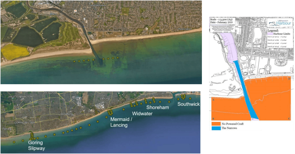
- Mermaid: Swim Area near The Perch restaurant in Lancing at 50°49′.1N 0°19′.3W
- Widewater: Swim Area adjacent to Widewater Lagoon at 50°49′.4N 0°17′.6W
- Shoreham: Swim Area west of Shoreham Harbour at 50°49′.5N 0°16′.6W
- Southwick: Swim Area east of Shoreham Harbour at 50°49′.6N 0°14′.2W


